Mission and System |
The Envisat-1 satellite has an ambitious and innovative payload that will ensure the continuity of the data measurements of the ESA ERS satellites. The Envisat-1 data will support Earth science research and allow monitoring of the evolution of environmental and climatic changes. Furthermore, they will facilitate the development of operational and commercial applications. |
 |
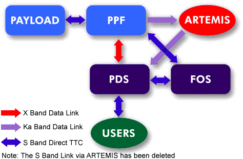
The Envisat-1 satellite works closely together with the Artemis data relay satellite (see the page on Artemis background information).

The Envisat satellite in flight
In flight, the major spacecraft longitudinal axis (the Xs-axis) is normal to the orbit plane, the Ys-axis is closely aligned to the velocity vector and the Zs-axis is Earth pointing. This configuration concept provides a large, modular, Earth-facing mounting surface for payload instruments and an anti-sun face for radiative coolers, free of occultation by satellite subsystem equipment.
For more information:
 Launch configuration
|
Dimensions | |
|
|
Dimensions (m) |
|---|---|
|
Launch Configuration |
length 10.5 m, envelope diameter 4.57m |
|
In-Orbit configuration |
26m * 10m * 5m |
|
Mass Budget | |
|
|
Mass (kg) |
|---|---|
|
Service Module |
2673 |
|
Payload Equipment Bay |
1021 |
|
Payload Carrier |
2078 |
|
Fuel |
319 |
|
Payload Instruments |
2118 |
|
Total |
8211 |
|
Power Budget | ||
|
|
Average Power (W) | |
|---|---|---|
|
|
Sunlight |
Eclipse |
|
Payload |
1841 |
1886 |
|
Payload Module |
860 |
527 |
|
Service Module |
859 |
684 |
|
Total Load |
3560 |
3097 |
|
System Capability |
3847 |
3291 |
The ground segment can be split into two major elements:
![[Kiruna Ground Station]](Mission%20&%20System%20Introduction_files/kiruna.jpg)
Kiruna ground station
The satellite-to-ground communication links will rely on
various ground stations (Kiruna, Fucino, Svallbard, and Villafranca - the
latter as TT&C back-up) and the ESA data relay satellite system Artemis
which will provide direct communication between Envisat-1 and the ground
even when the satellite is out of visibility of the ground stations. This
will enable the use of high rate sensors which cannot be be stored on board,
more optimally managed tape dumps, and enhanced visibility for command and
control. Additional national and ESA ground stations will be
involved.
![]()